Landowners have until July 11 to object
Farmers Forum staff
SOUTH DUNDAS — Eastern Ontario farmers are raising the alarm about a radical expansion of designated wetland on farms during planting and time is running short for the affected farmers to raise their objections.
It’s all because the Ford government quietly handed local watershed authorities the power to designate provincially significant wetlands on April 1. Now, those authorities have begun to flex their new muscles. They intend to colour the map with more and expanded wetlands in their areas of jurisdiction, South Dundas farmer and former mayor Steven Byvelds says.
Byvelds says the South Nation, Raisin Region and Rideau Valley conservation authorities are all involved in the joint exercise in much of what is considered traditional Eastern Ontario. “South Nation has basically made every bush a wetland (on the proposed map) and then challenged the landowners to object,” he complains.
Some of Byvelds’ own farmland, near Williamsburg, is implicated. He’s also unhappy to see the proposed designation slapped down on a ribbon of land between Highway 401 and Highway 2 in South Dundas.
Said a Moosecreek farmer: “It appears they just don’t want wooded areas to become farmland. They’re picking on dry land. It’s 97% dry land. It has nothing to do with wetlands.”





The last day for landowners to express their opposition to any changes is July 11. (The short consultation period began June 3.) Formal meetings were to conclude on June 27 but it’s still possible to request a one-on-one session by visiting the South Nation Conservation Authority website. The watershed boards were expected to approve the updated mapping later in July, but even then, the mapping would remain “fluid” and farmers could still request additional amendments, according to Rideau Valley Conservation Authority engineering and regulations director Terry Davidson, who also runs a farm near Kinburn.

The combined jurisdictions of the Rideau River, South Nation River, and Raisin River conservation authorities. The involved watershed authorities are proposing a significant expansion in the provincially significant wetlands in their respective jurisdictions.
South Nation Conservation spokesperson Erin Thorne blamed the province for the new wetlands push. Thorne explained that the province compelled the three involved watershed authorities to identify “locally significant” wetlands, even though they identified “provincially significant wetlands” years ago. Both types of designated wetland face the same restrictions from a landowner perspective, Thorne confirmed. “They are regulated the same way.”
The South Nation board can’t simply declare that the new locally significant wetlands are the same as the existing provincial wetlands and avoid the hassle. “They can’t override the regulation. We have to do it,” she said. “We didn’t even want to do this.” Thorne said the Eastern Ontario watershed authorities only learned on April 1 that they were required to update their wetland mapping. “It’s a government regulation and it’s creating so much work on our end. It’s something we have to do based on this new Ontario regulation … and I don’t know why the province is doing this.”
She said that the wetland push is not a desire to stop farmer clear-cutting.
No other Ontario watershed authorities are affected by the regulation because their mapping already includes locally significant wetlands, according to Thorne. The Eastern Ontario group didn’t designate that type of wetland when the other authorities did, about 15 years ago, and she could not explain the difference in designation criteria.
She acknowledged that a “wetland” doesn’t necessarily have to be swampy in order to be designated. It depends on the species of plants and animals in the suspected wetland. The involved watershed authorities are asking farmers to allow their staff to visit the affected properties to see if they actually qualify as wetlands. In some cases, proposed wetlands are being removed from the proposed mapping after a “boots on the ground” visit, she said.
Once a parcel of land is designated a “wetland,” it can’t be clear-cut into farmland or developed for housing. However, Thorne noted that the owner can still harvest firewood.
Farming activity is also allowed closer to wetlands these days, as the standard “buffer zone” is now 30 meters, not the old 120 meters, she said.
Thorne also said that building is still allowed within one of the newly designated wetland areas — so long as the application for the building permit is submitted to the local municipality before July 18.
Thorne also asked that Farmers Forum soften its online headline accompanying the initial version of this story, which stated, “Watershed authorities unleash sneak attack on dry, wooded land.”
Farmers Forum editor Patrick Meagher declined saying, “It looks pretty damned sneaky to me” but conceded that much of the blame lies with the province. The headline was changed to say that the watershed authorities “unleash provincial sneak attack on dry, wooded land.”
Contrary to a “sneak attack” on farmers as referenced in the story headline, the Conservation authority is seeking farmer input and wants to work with them through this process, Thorne said.
Crop farmer and Dundas Federation of Agriculture board member Jackie Kelly-Pemberton questioned why the province would compel wetland changes at this point in time. “Why now?” she said, and asked if it’s to make them fall in line with a policy carried out in the rest of Ontario’s watershed authorities, but what about those areas of the province lacking watershed authorities altogether? She pointed to the areas west of Arnprior as an example of this unequal treatment.
Other farmers are incensed that the consultation period falls in the middle of a tough planting season, and the time to respond is short. During a May 23 Zoom meeting with watershed officials, four local farm leaders say they were informed that designated wetlands in three conservation authority jurisdictions would be expanded and that farmer input was critical.
Kelly-Pemberton, who sits as a member of South Nation Conservation’s watershed advisory committee and took part in the Zoom call, said the Dundas federation updated its Facebook page with a link to the new wetland mapping on June 10.
Ontario Federation of Agriculture member services rep Ruth Vogel confirmed that the mapping was ready in time for the June 13 Grenville federation and June 20 Leeds federation meetings. Watershed officials gave presentations to the attending farmers on those occasions, she said.
Vogel said she’s been getting a lot of phone calls on the subject. She tells farmers that it’s important to attend the open house sessions or arrange to speak with their watershed authority before July 11. “At least let the conservation authorities know that … you don’t think your land should be categorized as a wetland.”
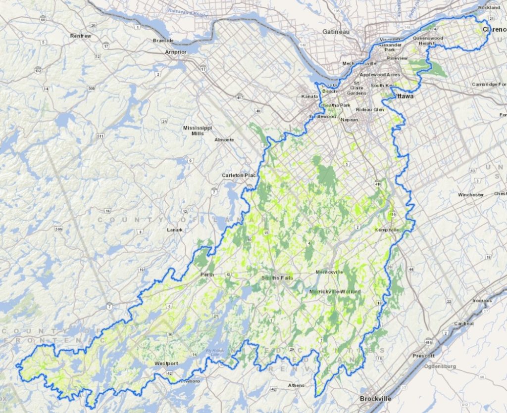
The dark green areas show current provincially significant wetlands within the Rideau River watershed. In light green are new provincially significant wetland areas proposed by the local watershed authority.
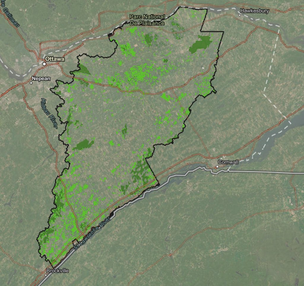
The dark green areas show current provincially significant wetlands within the South Nation River watershed. In light green are new provincially significant wetland areas proposed by the local watershed authority. It’s a similar story in the adjoining Raisin River watershed (to the immediate east), but that watershed authority doesn’t offer the same expanded view on its website.
CANCELLED: Wetland designation meetings cancelled June 26 to July 3